| . |  |
. |
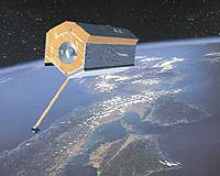
TerraSAR-X, the German all-weather satellite project, has entered its decisive phase. At the Friedrichshafen-based space company EADS Astrium, the final spurt for the development team has now begun with the start-up of the integration activities. As of April 2006, from an altitude of approximately 500 kilometres, TerraSAR-X is scheduled to deliver Earth observation data of new quality for scientific and commercial applications. TerraSAR-X is the first German space project implemented in a public/private partnership. Cooperation partners are the German Aerospace Centre (DLR, Cologne) and EADS Astrium GmbH. TerraSAR-X has been specifically designed for scientific and commercial use. Previously built Earth observation satellites do not or only partly meet the demands of private-sector users. Commercial users require detailed data adapted to their individual requirements. These data must be available quickly and reliably, that means often independent of daylight and weather conditions. This is exactly what TerraSAR-X offers. Data from Synthetic Aperture Radars (SAR) are particularly suitable for commercial exploration. The SAR instruments supply extremely detailed radar images, day and night, in all weather conditions. The German Aerospace Centre (DLR) will be responsible for the scientific use of the TerraSAR-X data, whereas commercial marketing will be performed exclusively by Infoterra GmbH (Friedrichshafen), a wholly-owned subsidiary of the European satellite company EADS Astrium- specialising in the collection and processing of air- and satellite-based data. Information from space is increasingly requested by the private sector. Today, satellite data are already widely used in commercial applications, such as infrastructure planning or the location of mineral resources, and to an increasing extent in agriculture and forestry. New-quality data records, as provided by TerraSAR-X, will also offer a vast amount of new research incentives- for instance in ecology, geology, hydrology and oceanography. The smallest movements of the Earth's surface (plate tectonics, volcanism, earthquake) are further scientific fields of application. In future, national security forces, disaster control organisations and the armed forces of the European countries will increasing rely on satellite information in the framework of their missions; the demand for global reconnaissance capability will further increase. "TerraSAR-X with its manifold technical possibilities" states Andreas Lindenthal, Director for Earth Observation and Science of EADS Astrium GmbH, "is excellently suited for making decisive contributions for meeting this information need".
Information from space for everyday life on Earth Just as the pictures from weather satellites have become a part of the daily television news broadcast, so could information from other Earth observation satellites become a part of our everyday lives. Companies from different branches, but also the public sector, are already using geo-information data acquired from space to optimise the production of their products and services:
In addition, it is also used for regional and urban planning, as well as for environmental protection purposes. Radar interferometry which allows the development of digital elevation models opens up new application dimensions. The use of these elevation models goes far beyond the production of topographic maps:
X-Band � A speciality of EADS-AstriumIn developing and building the TerraSAR-X system, EADS Astrium has drawn on a wealth of experience. In 1990 and 1994, the ERS 1 and ERS 2 satellites built under the system leadership of today's EADS Astrium on behalf of ESA were already placed in orbit. These satellites equipped with C-band radar instruments have successfully demonstrated the advantages of radar technology. With the shuttle radar mission in 1994, the X-SAR instrument built by EADS Astrium and financed by DLR provided further evidence of the capabilities of this Earth observation technology. In 2000, in the framework of another DLR-financed project, the Shuttle Radar Topography Mission (SRTM), new data were gathered with improved technology on board the space shuttle Endeavour which allowed a three-dimensional map of the Earth to be created.
TerraSAR-X The satellite is built on an octagonal structure about 5.20 metres long with a diameter of 2.20 metres. Its launching weight is a good ton. The technical highlight of the X-band satellite is the active radar instrument. This Synthetic Aperture Radar (SAR) enables very high image resolutions of up to one metre, independent of daylight or cloud cover. In addition, the active X-band antenna increases the flexibility and thereby the deployment spectrum of the satellite. While with passive systems the entire satellite must be rotated in order to aim the antenna on the target area, the active antenna of TerraSAR-X can steer the radar impulses in a certain direction or receive them from a certain direction. The antenna is 4.80 metres long and 0.80 metre wide. The satellite is built in such a way that it can be mounted with the antenna in full size on the launch rocket. This obviates a complicated folding mechanism. TerraSAR-X will circle the Earth at an altitude of approximately 500 kilometres. With every rotation, the satellite passes over the poles. While the Earth turns away beneath the satellite, TerraSAR-X sweeps the surface of the Earth in swaths. After a while, all regions of the Earth pass through the field of vision of the radar antenna. The choice of orbit and the flexibility of the radar instrument ensure that the satellite will be able to image every point on the Earth in a maximum of three days. The satellite can work in three different operational modes:
This allows the recognition of moved objects such as cars or ships. This application is of particular interest for traffic research. The radar data gathered by the satellite are initially stored on board and transmitted to the ground, when the satellite passes over the DLR ground station in Neustrelitz. Mission control is carried out by the German Space Operations Centre GSOC in Oberpfaffenhofen. Furthermore, it is possible to send radar data directly by satellite to interested customers around the world.
Public Private Partnership TerraSAR-X will be the first satellite implemented in a public/private partnership in Germany. The entire costs for development, construction and launch of TerraSAR-X will amount to approximately 130 million euros. The German Aerospace Centre (DLR) is investing 102 million and the space company EADS Astrium 28 million euros. A substantially greater sum of private funding by EADS Astrium is being invested in parallel in the development of geo-information products and their marketing. EADS Astrium and DLR have already expended substantial sums in the definition of TerraSAR-X, the development of data products and the extension of the ground infrastructure. TanDEM-X or dual TerraSAR-XOn behalf of the German Aerospace Centre (DLR), EADS Astrium currently analyses a tandem flight mission (called TanDEM-X) involving the use of a second satellite of the TerraSAR-X family. In this mission with a duration of up to five years, both satellites together would form a large radar interferometer. In a close, precisely controlled formation flight they will generate images similar to stereoscopic pictures with a relative height accuracy of less than two metres. Thus, the Earth can be acquired as a digital terrain model of unprecedented quality. Digital terrain models form the basis for many scientific applications and commercial evaluations. Examples are planning activities concerning transmission lines or transmit and receive stations in telecommunications. Traffic flow monitoring both in the air and on the roads would benefit from the novel satellite data. A global digital terrain model also enables improved evaluation of data received from reconnaissance satellites.
EADS SpaceDaily Search SpaceDaily Subscribe To SpaceDaily Express 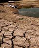 Rome, Italy (ESA) Nov 22, 2004
The severe droughts and forest fires of recent years underline Mediterranean Europe's continuing vulnerability to desertification � 300 000 square kilometres of territory are currently affected, threatening the livelihoods of 16.5 million Europeans. A new satellite-based service is set to provide a continuous monitoring of regions most at risk.
|
| ||||||||||
| The content herein, unless otherwise known to be public domain, are Copyright 1995-2016 - Space Media Network. All websites are published in Australia and are solely subject to Australian law and governed by Fair Use principals for news reporting and research purposes. AFP, UPI and IANS news wire stories are copyright Agence France-Presse, United Press International and Indo-Asia News Service. ESA news reports are copyright European Space Agency. All NASA sourced material is public domain. Additional copyrights may apply in whole or part to other bona fide parties. Advertising does not imply endorsement, agreement or approval of any opinions, statements or information provided by Space Media Network on any Web page published or hosted by Space Media Network. Privacy Statement All images and articles appearing on Space Media Network have been edited or digitally altered in some way. Any requests to remove copyright material will be acted upon in a timely and appropriate manner. Any attempt to extort money from Space Media Network will be ignored and reported to Australian Law Enforcement Agencies as a potential case of financial fraud involving the use of a telephonic carriage device or postal service. |