| . |  |
. |
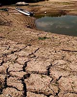
The severe droughts and forest fires of recent years underline Mediterranean Europe's continuing vulnerability to desertification � 300 000 square kilometres of territory are currently affected, threatening the livelihoods of 16.5 million Europeans. A new satellite-based service is set to provide a continuous monitoring of regions most at risk. ESA's DesertWatch project involves the development of a desertification monitoring system for the northern shores of the Mediterranean Sea, in support of responsible regional and national authorities. "Desertification is a common problem across Mediterranean nations, because of circumstances in common: similar historical backgrounds, climatic conditions, land use patterns, cultural characteristics and vegetation types," explained Dr. Mevlut Duzgun of the Turkish Ministry of Environment and Forestry, a DesertWatch partner user. "What we hope to get out of this project is the development of a common, harmonised information system available to all Mediterranean countries affected by desertification processes, making it possible to permanently access the data needed to monitor changes as they occur." The term 'desertification' refers not to the spread of existing deserts, but the creation of new ones through the degradation of susceptible arid or dryland ecosystems, which extend over a third of the Earth's land surface. Degradation is mainly due to human activities such as overfarming or land clearance, although drought also degrades the quality and productivity of soil and vegetation, and the impact of climate change remains an open question. Mismanagement of land strips nutrients from soil and diminishes vegetation cover. And without plants or trees to bind the soil together, topsoil that has taken centuries to accumulate is blown or washed away, further reducing the biological productivity of the land until finally it becomes useless. The Worldwatch Institute estimates the Earth's landmasses lose up to 24 thousand million tonnes of topsoil annually. "In the case of Turkey, our economy is highly dependent on agriculture, so soil is to be considered one of our major natural resources to be efficiently protected so a maximum level of productivity should be sustained," added Duzgun. "The total area affected by soil erosion mainly due to water but also wind is 57.6 million hectares � more than two thirds of the country. And our climate is such that large parts of the country are sensitive to wild fires." As a densely populated dryland zone, Mediterranean Europe would be vulnerable to desertification anyway, although regular forest fires make its situation worse. Between 600 000 and 800 000 hectares of Mediterranean forest is burnt annually � leaving an area approaching the size of Corsica stripped of vegetation. The World Wildlife Fund estimates that 95% of these fires are caused either by negligence or deliberate arson. The good news is that dryland desertification can be remedied or even reversed, using appropriate land management techniques. Forecasting is needed of areas most at risk, and this is what satellites can provide. As well as highlighting any relevant land use change, the view from space can reveal increased surface reflectivity, temperature, dryness and dustiness. Infrared sensors can be used to detect vegetation stress from environmental changes. During the lifetime of DesertWatch, data gathered from multiple spacecraft including ESA's Envisat will be used to assess desertification trends over time, developing standardised geo-information products to enable cross-border comparisons. DesertWatch products are also envisaged as a means for countries to fulfil their reporting obligations to the United Nations Convention on Combating Desertification (UNCCD), a 191-nation agreement to fight desertification on a global basis. Partner users for the DesertWatch project come from four Northern Mediterranean nations most affected by desertification. As well as the Turkish Ministry of the Environment and Forestry, they are Italy's National Committee to Combat Drought and Desertification, the Greek National Committee for Combating Desertification and Portugal's National Coordinating Body of the Portugal National Action Program on the UNCCD. These bodies are supplying user requirements to the project, and will also work to validate the DesertWatch information system. Part of ESA's Data User Element, the 24�month DesertWatch project began in September 2004. Italy's Advanced Computer Systems SpA is leading DesertWatch on behalf of ESA. Additional contributors include Spain's National Research Council � Arid Zones Research Station (EEZA), Italy's Ente per le Nuove Tecnologie, L'Energia e l'Ambiente in Rome (ENEA) and University of Sassari Desertification Research Group (NRD), the Research Institute for Knowledge Systems in the Netherlands (RIKS) and the Remote Sensing Department of the University of Trier in Germany. Related Links UN Convention to Combat Desertification DesertWatch website SpaceDaily Search SpaceDaily Subscribe To SpaceDaily Express  Washington DC (SPX) Nov 19, 2004
NASA and IUCN - The World Conservation Union, the world's largest environmental knowledge network, signed a joint declaration today in Bangkok, Thailand, to use NASA satellite data to help in worldwide conservation efforts.
|
| ||||||||||
| The content herein, unless otherwise known to be public domain, are Copyright 1995-2016 - Space Media Network. All websites are published in Australia and are solely subject to Australian law and governed by Fair Use principals for news reporting and research purposes. AFP, UPI and IANS news wire stories are copyright Agence France-Presse, United Press International and Indo-Asia News Service. ESA news reports are copyright European Space Agency. All NASA sourced material is public domain. Additional copyrights may apply in whole or part to other bona fide parties. Advertising does not imply endorsement, agreement or approval of any opinions, statements or information provided by Space Media Network on any Web page published or hosted by Space Media Network. Privacy Statement All images and articles appearing on Space Media Network have been edited or digitally altered in some way. Any requests to remove copyright material will be acted upon in a timely and appropriate manner. Any attempt to extort money from Space Media Network will be ignored and reported to Australian Law Enforcement Agencies as a potential case of financial fraud involving the use of a telephonic carriage device or postal service. |