| . |  |
. |
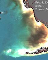
For the first time, scientists may now detect a phytoplankton bloom in its early stages by looking at its red "glow" under sunlight, due to the unique data from two NASA satellites. According to a study conducted in the Gulf of Mexico, this phenomenon can forewarn fishermen and swimmers about developing cases of red tides that occur within plumes of dark-colored runoff from river and wetlands, sometimes causing "black water" events. Dark-colored river runoff includes nitrogen and phosphorus, which are used as fertilizers in agriculture. These nutrients cause blooms of marine algae called phytoplankton. During extremely large phytoplankton blooms where the algae is so concentrated the water may appear black, some phytoplankton die, sink to the ocean bottom and are eaten by bacteria. The bacteria consume the algae and deplete oxygen from the water that leads to fish kills. Chuanmin Hu and Frank Muller-Karger, oceanographers at the College of Marine Science of University of South Florida, St. Petersburg, Fla., used fluorescence data from NASA's Moderate Resolution Imaging Spectroradiometer (MODIS) instruments aboard both NASA's Terra and Aqua satellites. MODIS detects the glow or phytoplankton fluorescence, from the plant's chlorophyll. The human eye cannot detect the red fluorescence. The ability to detect glowing areas of water helps researchers identify whether phytoplankton are present in large dark water patches that form off the coast of Florida. Without these data, it is impossible to differentiate phytoplankton blooms from plumes of dark river runoff that contain few individual phytoplankton cells. Because colored dissolved organic matter that originates in rivers can absorb similar amounts of blue and green color signals as plants do, traditional satellites that simply measure ocean color cannot distinguish phytoplankton blooms within such patches. Although satellites cannot directly measure nutrients in lakes, rivers, wetlands and oceans, remote sensing technology measure the quantities of plankton. Scientists can then calculate how much nutrient might be needed to grow those amounts of plankton. Hu and others used this technique to study the nature and origin of a dark plume event in the fall of 2003 near Charlotte Harbor, off the south Florida coast. Moderate concentrations of one of Florida's red tide species, were found from water samples. "Our study traces the black water patches near the Florida Keys to some 200 kilometers (124 miles) away upstream," said Hu. "These results suggest that the delicate Florida Keys ecosystem is connected to what happens on land and in two remote rivers, the Peace and Caloosahatchee, as they drain into the ocean. Extreme climate conditions, such as abnormally high rainfall in spring and summer 2003, may accelerate such connections," he added. These findings are based on scientific analyses of several things. Data used include satellite ocean color from MODIS and Sea-viewing Wide Field-of-view Sensor (SeaWiFS), and wind data from NASA's QuikSCAT satellite. US Geological Survey, National Oceanic and Atmospheric Administration (NOAA), Florida�s Fish and Wildlife Research Institute, and other organizations provided rain, river discharge, and field survey information. By knowing which way the winds blow and the currents flow, Hu and colleagues can predict where black water may move. Red tides occur every year off Florida and are known to cause fish kills, coral stress and mortality, and skin and respiratory problems in humans. Previous studies show that prolonged "black water" patches cause water quality degradation and may cause coral death. The use of remote sensing satellites provides effective means for monitoring and predicting such events. The link between coastal runoff and black water events is an example of how land and ocean ecosystems are linked together. "Coastal and land managers over large areas need to work together, to alleviate more black water events from taking place in the future," said Muller-Karger. This study appeared in a recent issue of the American Geophysical Union's Geophysical Research Letters. Coauthors of the article include Gabriel Vargo and Merrie Beth Neely from University of South Florida and Elizabeth Johns from NOAA's Atlantic Oceanographic and Meteorological Laboratory. NASA's Science Directorate works to improve the lives of all humans through the exploration and study of Earth's system, the solar system and the Universe. Related Links SpaceDaily Search SpaceDaily Subscribe To SpaceDaily Express  Austin TX (SPX) Aug 26, 2004
Engineers at The University of Texas at Austin have developed the capability for measuring large-scale changes in the Earth's water availability. The development, reported in the July 23 issue of Science, will make climate change studies much more accurate. New, More Accurate Measurements Of Earth's Water Distribution
Austin TX (SPX) Aug 26, 2004Engineers at The University of Texas at Austin have developed the capability for measuring large-scale changes in the Earth's water availability. The development, reported in the July 23 issue of Science, will make climate change studies much more accurate.
|
| ||||||||||
| The content herein, unless otherwise known to be public domain, are Copyright 1995-2016 - Space Media Network. All websites are published in Australia and are solely subject to Australian law and governed by Fair Use principals for news reporting and research purposes. AFP, UPI and IANS news wire stories are copyright Agence France-Presse, United Press International and Indo-Asia News Service. ESA news reports are copyright European Space Agency. All NASA sourced material is public domain. Additional copyrights may apply in whole or part to other bona fide parties. Advertising does not imply endorsement, agreement or approval of any opinions, statements or information provided by Space Media Network on any Web page published or hosted by Space Media Network. Privacy Statement All images and articles appearing on Space Media Network have been edited or digitally altered in some way. Any requests to remove copyright material will be acted upon in a timely and appropriate manner. Any attempt to extort money from Space Media Network will be ignored and reported to Australian Law Enforcement Agencies as a potential case of financial fraud involving the use of a telephonic carriage device or postal service. |