| . |  |
. |
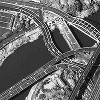
Space Imaging is nearing completion of a contract to provide imagery to the Department of Defense (DOD) for improved situational awareness of major defense installations. The contract was awarded in February 2003 by the National Geospatial-Intelligence Agency (NGA) and will serve as a critical, geo-referenced, common installation picture to help the Armed Forces begin a military transformation to reconfigure and reposition themselves for 21st century threats. The Assistant Secretary of Defense for Acquisition, Technology and Logistics tapped the Air Force's GeoBase program in April 2003 to coordinate the DOD effort. With a simple vision of 'One Installation ... One Map,' GeoBase integrates numerous geospatial data sets to maps, thereby providing a single point of access to military base information. In early 2003, highly accurate Precision 1-meter IKONOS satellite imagery produced by Space Imaging was selected by NGA as the imagery component for this unprecedented DOD mapping effort. Not only did the IKONOS product satisfy the technical criteria for the project, but Space Imaging also had a significant inventory of installation imagery in its immense archive to help meet the short timeline of early 2004 delivery. The mapping effort will complement the USAF's GeoBase program investments, as well as the Army's parallel GIS-R (GIS Repository) and the Navy's GeoReadiness programs. The services will be overlaying legal base boundaries, noise contours, accident potential zones, explosive safety arcs (for firing and bombing ranges), 100- year floodplains and wetlands features on the imagery so that senior leaders are able to more readily appreciate the complex military-civil environment as they address strategic basing decisions. When complete, this initial phase of the DOD installation visualization effort will include more than 300 defense sites from across the services, mostly in the continental United States, Hawaii, Alaska and Guam. According to Colonel Brian Cullis, (USAF), who is responsible for the DOD effort, "Space Imaging's Precision 1-meter IKONOS imagery was selected for our use because it provided the right image, with the right accuracy and resolution, in the timeframe required." "The data provided to DOD in coordination with the National Geospatial- Intelligence Agency is an example of how innovative military and civilian leaders are using space-based technology to gain a better understanding of their particular battlespace," said Jim Youker, Space Imaging's director of Military Programs. "In this case, imagery is being used to help the Secretary of Defense better manage critical infrastructure." Related Links Space Imaging SpaceDaily Search SpaceDaily Subscribe To SpaceDaily Express 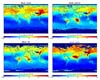 Huntsville (SPX) May 20, 2004
Data from NASA's Terra satellite is adding to our understanding of how pollution spreads around the globe. The information will help scientists protect and understand the Earth.
|
| ||||||||||
| The content herein, unless otherwise known to be public domain, are Copyright 1995-2016 - Space Media Network. All websites are published in Australia and are solely subject to Australian law and governed by Fair Use principals for news reporting and research purposes. AFP, UPI and IANS news wire stories are copyright Agence France-Presse, United Press International and Indo-Asia News Service. ESA news reports are copyright European Space Agency. All NASA sourced material is public domain. Additional copyrights may apply in whole or part to other bona fide parties. Advertising does not imply endorsement, agreement or approval of any opinions, statements or information provided by Space Media Network on any Web page published or hosted by Space Media Network. Privacy Statement All images and articles appearing on Space Media Network have been edited or digitally altered in some way. Any requests to remove copyright material will be acted upon in a timely and appropriate manner. Any attempt to extort money from Space Media Network will be ignored and reported to Australian Law Enforcement Agencies as a potential case of financial fraud involving the use of a telephonic carriage device or postal service. |