| . |  |
. |
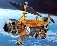
Thanks to wider government support, international cooperation and innovative value-added products, the commercial and civil remote sensing market has strengthened significantly over the past year. According to a recent analysis by Forecast International, "The Market for Civil and Commercial Remote Sensing Satellites," approximately 170 remote sensing satellites will be manufactured between 2004 and 2013, 130 of which are slated for production within the next five years. Forecast International's reported value of production for these systems is approximately $15.5 billion, with $10.1 billion of that amount being generated in the first half of the 10-year forecast period. The commercial and civil remote sensing market can be broken down into two categories: Geosynchronous Earth Orbit (GEO) systems and Low Earth Orbit (LEO) systems. The GEO systems are mostly used to monitor global climate and the weather conditions on Earth. In contrast to LEO systems, GEO spacecraft usually feature complex payloads that contribute to their higher costs. For that reason, although the GEO sector represents a tiny portion of the civil remote sensing market in terms of production - only 10 satellites expected over the next 10 years - it accounts for almost $1.4 billion of the overall value of production. Not bad considering that the 161 LEO systems earmarked for production during the period are expected have a total estimated value of $14.1 billion. With that in mind, Alcatel Space is expected to retain an approximate 30 percent market share in the defined GEO segment, in both unit production and value. Astrium, Boeing, Northrop Grumman, and Orbital Sciences will each carry a 10 percent market share in terms of unit production. As for LEO systems "The top unit producer is expected to be Surrey Satellite Technology Ltd (SSTL), which is projected to earn 11.9 percent of total unit production over the next 10 years," said John Edwards, Forecast International Space Systems Analyst. Surrey Satellite's Disaster Monitoring Constellation (DMC) is one of the major components in this category, simply because it offers a wealth of remote sensing knowledge and capabilities to nations that otherwise could not have developed such technology on their own in the near term. "Because Surrey's low-cost DMC program has been received so well worldwide, the firm is reportedly considering a second generation system that will most likely involve different nations," Edwards said. Following SSTL in terms of market share is the European favorite Astrium, which is expected to capture 8.8 percent of the LEO market. Fast on the heels of Astrium is the Indian Space Research Organization, ISRO, which has a large batch of production planned, totaling about 8.1 percent of the LEO market. In the United States, 2003 was a pivotal year for the commercial and civil remote sensing industry. Much needed support was ultimately forthcoming from the U.S. government through a $500 million NextView contract. This contract not only guarantees U.S. access to imagery products for the next five years, but also gives the winner of the contract, DigitalGlobe, a substantial leg up on the competition. "DigitalGlobe has the advantage right now and likely will in the near future," Edwards said, referring to the termination of the U.S. government's discussions to pursue a second $500 million contract with Space Imaging, Digital Globe's competitor. According to the most recent remote sensing policy, released in May 2003, the U.S. government's goal is to foster healthy competition in the remote sensing market and to protect U.S. national security and foreign policy interests. "The recent breakdown in contract negotiations with Space Imaging appears to run counter to that ambition," Edwards said. On the international front, "Cooperative international civil programs will continue to promote moderate levels of remote sensing satellite production during the forecast period," Edwards said. Systems like COSMO-Pleiades and SSTL's Disaster Monitoring Constellation are expected to validate the efficiency and benefits of becoming part of a cooperative remote sensing partnership. These successes, in turn, will encourage more nations to form cooperative partnerships to receive greater scientific return with dramatically lower investment and risk. Forecast International believes that faster data distribution rates and enhanced imagery processing and packaging services will drive the growth of the remote sensing market. Resolution technology that offers the possibility of reading a newspaper from space is not only restricted commercially under current U.S. laws, but is also not practical or necessary for most applications. Further, the prohibitive costs associated with high resolution images make them unobtainable for institutions with limited budgets. For this reason, Edwards said, "government agencies will remain the largest consumer of remote sensing goods and services until increased competition eventually brings prices down." In the future, lower costs associated with a competitive environment, will eventually allow a practical accessibility of this data to small businesses, communities and institutions of limited financial means. Encouraged by growth in this market, most major entities in the remote sensing industry are preparing next-generation spacecraft and capabilities to be fielded within the forecast period. With key anchor customers either signing on or showing interest, current market indicators point to a healthy commercial and civil remote sensing industry over the next 10 years. Forecast International, Inc., is a leading provider of Market Intelligence and Analyses in the areas of aerospace, defense, power systems and military electronics. Based in Newtown, CT, USA, Forecast International specializes in long-range industry forecasts and innovative marketing presentations, including regular 10-year forecasts. Related Links Forecast International SpaceDaily Search SpaceDaily Subscribe To SpaceDaily Express 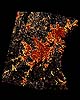 Greenbelt MD - Mar 26, 2004
According to NASA-funded researchers, developed land in the greater Washington-Baltimore metropolitan area is projected to increase 80 percent by 2030. Scientists used a computer-based decision support model loaded with NASA and commercial satellite images to simulate three policies affecting land use.
|
| ||||||||||
| The content herein, unless otherwise known to be public domain, are Copyright 1995-2016 - Space Media Network. All websites are published in Australia and are solely subject to Australian law and governed by Fair Use principals for news reporting and research purposes. AFP, UPI and IANS news wire stories are copyright Agence France-Presse, United Press International and Indo-Asia News Service. ESA news reports are copyright European Space Agency. All NASA sourced material is public domain. Additional copyrights may apply in whole or part to other bona fide parties. Advertising does not imply endorsement, agreement or approval of any opinions, statements or information provided by Space Media Network on any Web page published or hosted by Space Media Network. Privacy Statement All images and articles appearing on Space Media Network have been edited or digitally altered in some way. Any requests to remove copyright material will be acted upon in a timely and appropriate manner. Any attempt to extort money from Space Media Network will be ignored and reported to Australian Law Enforcement Agencies as a potential case of financial fraud involving the use of a telephonic carriage device or postal service. |