| . |  |
. |
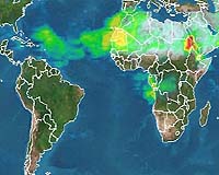
The other side of the world could be closer than you think. Little pieces of Earth, particles of dust, can travel halfway around the globe and alter air quality, affecting animals, plants and weather. Summer storms from the planet's deserts kick up literally millions of tons of dust, and winds send it flying to far-flung destinations where it clogs our lungs, changes soil chemistry, deposits minerals in bodies of water and reflects the Sun's rays back into space. In July 2000 alone, nearly 8 million tons of dust from Africa's Sahara desert reached as far west as Puerto Rico. "If you figure that a pickup truck weighs 1 metric ton, that dust weighed as much as 8 million pickups," says NASA aerosol researcher Dr. Peter Colarco. Colarco works to create computer simulations that forecast the movement of dust given current weather conditions. NASA and its partner agencies want to know what drives the movement of this dust and how exactly the dust changes our environment, not only so scientists can better understand the health of our planet, but also so they can predict where dust will imminently affect people. Take the case of Africa. Winds blow twenty percent of dust from a Saharan storm out over the Atlantic Ocean, and twenty percent of that, or four percent of a single storm's dust, reaches all the way to the west side of the Atlantic. The remainder settles out into the ocean or washes out of the air with rainfall. Scientists think that the July 2000 measurements, made in Puerto Rico, equaled about one-fifth of the total year's dust deposits. If these estimates hold true over the long term, then the entire state of Florida receives about three feet of dust every million years. Coupled with normal urban pollution from factories and cars on a summer day, dust can aggravate asthma and, in large enough quantities, potentially push cities in its path out of compliance with air quality standards such as those set by the United States' Environmental Protection Agency (EPA). For the past 20 years, "people [thought] of dust in the air residing between 2 and 5 kilometers above Earth, where it blocks the Sun but not much else," Colarco adds. This may still hold true for summer dust storms from Africa, but new research shows dust transport can be much more complicated.
From Particle to Prediction PRIDE provided an important framework for evaluating our understanding of dust transport mechanisms across the tropical North Atlantic Ocean. PRIDE operated from June 28 to July 24, 2000, from the Roosevelt Roads Naval Station on the eastern side of Puerto Rico, and provided data used in Colarco's research. PRIDE was a joint US Navy/NASA field program led by the Navy's Space and Naval Warfare Systems Center, San Diego (SPAWAR San Diego), the University of Miami, and NASA Goddard Space Flight Center. Other organizations that took part in the PRIDE experiment include: the NASA Ames Research Center, the Naval Research Laboratory, University of Maryland-Baltimore County, University of Alabama-Huntsville, University of Colorado, SRI International, the Bay Area Environmental Research Institute and Science Systems and Applications, Inc. Their combined surface, airborne, and satellite studies aimed to discover how the dust reflects light over land and water, moves over time, and affects clouds. The results would then be used to evaluate current theories of dust movement and create new models, if need be. Besides quantifying the amount of dust from Africa that reaches North America, the work of the PRIDE researchers led Colarco, then a graduate student doing NASA-funded research at the University of Colorado, and his collaborators to several important new ideas about where and how the dust travels. Their findings support a hypothesis that rather than individual Saharan storms sending clouds of dust across the ocean, a "reservoir" of dust particles hovers over Africa, and the dust at Puerto Rico came almost solely from Africa, with little from Arabia or Asia. Thus, these new ideas suggest that only when winds and other transport conditions are right over Africa does dust get pushed out over the Atlantic, independent of dust storms underway. So isolated storms may not be responsible for the dust blowing across the ocean. Every summer, cool, moist air flows from the Mediterranean Sea over the Sahara. The hot, dry desert warms the air, which moves upward, taking dust with it. Scientists have thought this dust-laden air layer, known as the Saharan Air Layer (SAL), stretches from the surface to about four miles above the Earth while it's over land. Once over the ocean, they thought coastal trade winds cut out the bottom of the layer, leaving a dust void from the surface to about a mile above the surface. At the same time, air circulation causes the dust to sink, lowering the top of the layer. Then, scientists believed, by the time the SAL reaches the Caribbean, rainfall has washed a large portion of dust into the ocean, and the layer ends up only about one mile thick. At this point, the bottom hovers at two miles above the Earth's surface, with the dust relatively evenly distributed throughout. However, the work of PRIDE researchers and Colarco cast doubt on such a simple profile of the dust layer. By comparing different proposed models of dust transit to the data collected in Puerto Rico, Colarco, then part of the Goddard Earth Sciences and Technology Center in collaboration with the University of Maryland, Baltimore County, simulated the distribution of dust vertically above the Earth's surface. He determined that the classic, evenly distributed Saharan Air Layer theory only proves true some of the time. At times, the layer varied more in distribution: either dust concentrated more heavily near the Earth's surface or it mixed evenly from the surface to just over 2 miles up, without the void at the surface and with a lower top than the classic SAL. The lower-level dust mostly traveled across the ocean several miles above the planet's surface, then settled down, rather than starting low and moving across the ocean closer to the surface. Gravity and downward moving winds caused much of the settling to lower levels in the clouds, though low-level rainfall also plays a role in this process. Colarco's theories have competition not only from the earlier models but also from alternatives proposed by other PRIDE researchers, such as a wind-based mechanism for the varied dust distribution in the air layer. As with many scientific endeavors, it seems once again more information, while answering some questions, also leads to more questions. With satellites and ground stations continuing to take measurements, scientists will be able to compare the theories to the data and ultimately resolve the true mechanism.
Who Wants to Know Where the Dust Goes? Dust may be more than just dust: researchers such as Eugene Shinn and colleagues at the United States Geological Survey (USGS) have begun preliminary studies showing that these Saharan transports can also carry to the Caribbean microscopic organisms such as a fungus known to cause a coral-reef-killing disease. On the other hand, the minerals in dust, such as iron, aluminum, calcium, magnesium, and potassium in the case of the Saharan dust, alter the chemical composition of the ocean it settles into to the benefit of some other species. Iron and aluminum, especially, provide necessary nutrients to the tiny plant life, phytoplankton, that form the bottom of the ocean food chain. Increasing the population of this rung of the ladder can potentially explode the populations of larger species that feed on the phytoplankton, changing the balance of oceanic life. Or this iron influx could increase the populations of harmful species of algae such as those that cause red tides, killing birds and other wildlife, shifting the marine balance in another direction. Finally, when it gets back to land, that dust can impact air quality, respiratory health, and climate processes that even more directly impact human life. This haze wreaks havoc with lung function, hitting asthmatics especially hard. People wishing to exercise outdoors find it harder to breathe on "bad air" days. These reversible, short-term exposure consequences have long-term counterparts such as chronic coughing and lung cancer, says the World Resources Institute, and environmental research and policy firm, basing their findings on World Health Organization work. In the United States, the Environmental Protection Agency (EPA) tracks particles in the air as one of its pollution measures. Joseph Prospero of the University of Miami tracks dust impact specifically on the city of Miami at the southern tip of Florida. With its large urban population, Miami faces pollution problems similar to those of other major U.S. cities. Urban pollution typically results from factories and vehicles in the city and immediate surroundings; however, Miami faces the additional onslaught of summer dust storms as a detriment to local air quality. Prospero postulates that the storms could bring enough particles to Miami that, on a summer day already high in particulate matter from local sources, the added dust could put Miami out of compliance with EPA standards for the day. However, the EPA's dust tracking does not spell disaster for Miami and other affected cities. The cities pushed out of compliance due to such "uncontrollable natural source" events face no consequences. In fact, it is thanks to NASA's satellites that the EPA can track these events at all; the agency's judgment of whether or not the elevated particulate levels result from dust storms or other unavoidable events come either from direct visual evidence or from NASA satellite images. Images from NASA's MODerate resolution Imaging Spectroradiometer (MODIS) aboard the Terra and Aqua satellites, available daily, usually make it "pretty easy" for agency experts to see that a dust storm is on its way, says EPA Associate Director for Science/Policy John Bachmann. Short- and long-term climatological and environmental effects accompany these health effects. Dust changes the relative amounts of sunlight reflected back to space and absorbed by our atmosphere. Scientists find this generally results in a warmer atmosphere and cooler surface, which alters weather, both regionally and eventually globally. The chemicals in dust deposited into waters and on land can alter water and soil chemistry, acting as fertilizer for some and poison for other animals and plants. Finally, from a more aesthetic, quality of life standpoint, dust in the atmosphere creates a haze, reducing visibility for sky watchers and others looking for a scenic view.
The Far-Flung Future of Dust Research Those scientists create computer simulations designed to predict where dust will go, given certain climate conditions. Weather forecasters do the same thing - use computer models based on years of observation to predict amounts of rainfall, wind speeds and directions, and temperatures. Scientists continue to collect data to create more accurate models and more precise forecasts. Once the scientists working in Puerto Rico gathered their on-site data, Colarco tested his models of dust movement to see if they accurately reflected the real data. Colarco's modeling research combines rules that scientists think govern the movements of winds, rain, and chemicals through our atmosphere into a simulation that he expects will give scientists an idea of where dust coming off Africa will go, given the current weather conditions. The more real data he gets to strengthen these rules and how they interact, the more accurate his simulation and forecast is. His models rely on a model of dust emission from another NASA/university collaboration, led by Paul Ginoux, then of the Georgia Institute of Technology, now at Princeton University working with the NOAA Geophysical Fluid Dynamics Laboratory. Colarco compared his model's predictions with data from PRIDE and satellites such as NASA's Total Ozone Mapping Spectrometer (TOMS) aboard the Earth Probe satellite and the National Oceanic and Atmospheric Administration's (NOAA's) Advanced Very High Resolution Radiometer (AVHRR) aboard the NOAA-14 polar orbiting satellite. Colarco's models proved very accurate in predicting the dust plume's position off of Africa, but moved the plume southward of its position determined by satellites as the dust moved across the ocean, sometimes missing the dust's arrival at Puerto Rico completely. When describing the vertical height of the dust at Puerto Rico, again the model worked fairly well, but sometimes placed the dust too high, possibly due to the coarse vertical resolution of the model. Finally, model estimates of the amount of dust deposition in Puerto Rico came close to the observed results from ground measurements. Obviously, scientists have reason to keep their eyes on the skies, watching for those plumes of dust rolling in, and hopefully eventually forecasting them. MODIS captures images in visible wavelengths, where dust is easily spotted over water. Over land, however, the dust is as bright as the Earth's surface and disappears from visible images. TOMS uses ultraviolet wavelengths to image the Earth, helping with this problem, but it doesn't take pictures as close-up as MODIS. Aura, the latest satellite to measure ozone and aerosols in NASA's Earth-observing arsenal, should continue TOMS' pictures at higher resolution when it launches in 2004. Satellites, however, must rely on indirect measurements of properties of dust, as they can't physically sample the dust. By using a vast array of tools such as those involved in PRIDE, Earth scientists can verify satellite data in order to ultimately develop a near-daily global picture of aerosol transport. This record will add to NASA's years of observations, creating a multi-year picture of global aerosols, part of the larger issue of Earth observation, monitoring the planet for its continued well being. Colarco's research appeared in the Journal of Geophysical Research � Atmospheres on July 12, 2003 and August 6, 2003. Colarco, who published the findings while working for the Goddard Earth Sciences and Technology Center, is now a NASA scientist at the University of Maryland's Earth System Science Interdisciplinary Center. Related Links SpaceDaily Search SpaceDaily Subscribe To SpaceDaily Express  Paris (ESA) Feb 09, 2004
Around 7pm CET [1800 UTC] on 28 January 2004, ESA's Envisat spacecraft completed its ten thousandth orbit of the Earth -- travelling a distance of 450 million kilometres since launch, equivalent to taking a trip to Mars.
|
| ||||||||||
| The content herein, unless otherwise known to be public domain, are Copyright 1995-2016 - Space Media Network. All websites are published in Australia and are solely subject to Australian law and governed by Fair Use principals for news reporting and research purposes. AFP, UPI and IANS news wire stories are copyright Agence France-Presse, United Press International and Indo-Asia News Service. ESA news reports are copyright European Space Agency. All NASA sourced material is public domain. Additional copyrights may apply in whole or part to other bona fide parties. Advertising does not imply endorsement, agreement or approval of any opinions, statements or information provided by Space Media Network on any Web page published or hosted by Space Media Network. Privacy Statement All images and articles appearing on Space Media Network have been edited or digitally altered in some way. Any requests to remove copyright material will be acted upon in a timely and appropriate manner. Any attempt to extort money from Space Media Network will be ignored and reported to Australian Law Enforcement Agencies as a potential case of financial fraud involving the use of a telephonic carriage device or postal service. |