| . |  |
. |
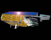
CryoSat, the ice research satellite developed and built by EADS Astrium for the European Space Agency ESA, is nearing completion at a fast pace. The mechanical integration and the functional tests are in full swing at the Friedrichshafen based satellite centre. In spring 2004, CryoSat is to be transported to Munich for conducting tests under space conditions. Following successful testing, there is nothing to prevent its launch from the Plesetsk Cosmodrome in Russia. The launch is scheduled in autumn 2004 on board a Rockot launcher. CryoSat is the next European environmental and climate satellite. Placed in a polar orbit it will measure changes in the thickness of ice sheets and polar ocean sea-ice cover for at least three years with unprecedented accuracy. The satellite will provide climate researchers with previously unavailable data from these uninhabited regions. The industrial contract amounts to some 70 million euros. The evidence of climate warming can be ignored no longer. As reported by the Intergovernmental Panel on Climate Change (an international board of climate experts), the average global surface temperature rose by 0.6 degrees in the 20th century. Climate data indicate that the 20th century was the warmest in the last thousand years. At the same time, since 1750, the concentration of greenhouse gases in the atmosphere, such as carbon dioxide and methane, has grown by 30 and 150 percent respectively as a result of human activities. Using the models available at the moment, it is only partially possible to predict how these developments affect the climate. The predictions waver between a global warming of between 1.4 to 5.8 degrees Centigrade in the next hundred years. As a consequence, experts expect some polar ice and glaciers to thaw. This could result in the water level of the oceans rising by up to a metre.
Polar ice as a climate factor
Three aspects are most important:
Polar ice reflects a large portion of the sunlight, and the amount of the absorbed and reflected light is balanced with the climate. If the polar ice begins to melt, less sunlight is reflected and therefore the polar region warms up. Consequently, more ice begins to melt and the reflective capabilities are thus further reduced. Due to this positive feedback effect, a self-accelerating warming ensues. In the night, open water radiates a large heat output of about 90 Watts per square metre. A snow-covered sea-ice slab floating upon the ocean beneath has a negative effect on this. To a certain extent, it acts as a thermal blanket and therefore plays a significant part in regulating the heat balance of the Earth. This effect is reduced as soon as the ice thins or decreases in extent. Ocean currents have a special influence on the climate. They act as heat pumps, as they disseminate the energy stored in the oceans around the entire globe. The most well known example is the Gulf Stream, which transports warm water from the tropics diagonally over the Atlantic to North Europe and provides Great Britain with a mild climate and ice-free ports up to North Scandinavia. If the ice sheets and the outer sea ice cover melt, the relatively larger quantities of fresh water could disrupt or even change these ocean currents � with unforeseeable effects for the climate.
CryoSat � the first mission of the "Living Planet" Programme CryoSat is to fill in this gap in climate research. The satellite will start as the first Earth Explorer Mission of ESA�s "Living Planet" programme initiated in 1998. The aim of this research programme is to give answers to the urgent scientific questions. The "Living Planet" programme is pursuing two strategies: First, the so called Core Explorer Missions which are relatively complex and cost intensive Earth observation missions for scientific purposes and second, the Opportunity Missions using mature technology thus enabling fast and low cost project implementation. CryoSat will be the first Earth Explorer Opportunity Mission. In July 1998, ESA called upon all scientists from its member countries for mission proposals for this programme. Researchers from University College London and other collaborating institutes, were supported by employees of Astrium in proposing CryoSat. Astrium�s early commitment in this mission ensuring low cost feasibility by simple and reliable technical concepts as early as in the first phase was unusual. In April 1999, the ESA programme committee selected CryoSat from a total of 27 submitted projects.
Radar altimeter measures ice thickness CryoSat, on the other hand, has two antennas. Similar to the way in which humans, with two eyes, can see spatially, CryoSat�s double radar will be able to scan the upper surface very precisely. Experts call this radar interferometry. With this system, an average accuracy of one to three centimetres can be reached. Thus it can also collect data on inhomogeneous ice structures in the polar seas and glaciers or ice sheets with very steep walls. In order for this extreme precision of measurement to be attained, the orbiting altitude of the satellite must be constantly known. To determine this to within a few centimetres, ground stations emit signals, which are received and processed by an instrument named DORIS. The information about altitude, which is thereby produced, is then conveyed via the normal data stream to the ground station. CryoSat�s outer side also sports a laser retro reflector. Similar to cats� eyes in warning posts on the edge of a road, it reflects a ray of light. If one were to send a laser beam to CryoSat from a ground station and receive the reflected signal from the satellite, one would be able to determine the height of the satellite from the transit time. CryoSat�s radar altimeter functions regardless of daylight and can also penetrate clouds. Therefore, it is particularly suited to the research of the large polar ice sheets, which rise up to 4000 metres above sea level and which are often covered by clouds. The data from the CryoSat mission are to deliver information about the rate of change of these ice sheets.
Working with a tight budget From the beginning, the special challenge of the CryoSat project for the EADS Astrium�s engineers was the apparently contradictory requirements of high reliability, fast realisation and a low cost. In the meantime, the satellite architecture of disarming simplicity and the proven hardware components supplied by the subcontractors have shown that the programme can be implemented as scheduled. The close partnership between scientists, ESA and the industrial consortium enables a lean management and, at the same time, more transparency and faster reaction time during the development and construction phases. Related Links EADS Astrium CryoSat SpaceDaily Search SpaceDaily Subscribe To SpaceDaily Express  Madison - Nov 05, 2003
Since October 8, UW�Madison's Lidar group has helped NASA test its ICEsat, the Ice, Cloud and land Elevation Satellite that is studying changes in polar ice thickness and extent.
|
| ||||||||||
| The content herein, unless otherwise known to be public domain, are Copyright 1995-2016 - Space Media Network. All websites are published in Australia and are solely subject to Australian law and governed by Fair Use principals for news reporting and research purposes. AFP, UPI and IANS news wire stories are copyright Agence France-Presse, United Press International and Indo-Asia News Service. ESA news reports are copyright European Space Agency. All NASA sourced material is public domain. Additional copyrights may apply in whole or part to other bona fide parties. Advertising does not imply endorsement, agreement or approval of any opinions, statements or information provided by Space Media Network on any Web page published or hosted by Space Media Network. Privacy Statement All images and articles appearing on Space Media Network have been edited or digitally altered in some way. Any requests to remove copyright material will be acted upon in a timely and appropriate manner. Any attempt to extort money from Space Media Network will be ignored and reported to Australian Law Enforcement Agencies as a potential case of financial fraud involving the use of a telephonic carriage device or postal service. |