| . |  |
. |
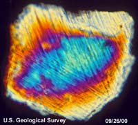
What happens when a comet or asteroid more than a mile wide slams into the Earth at supersonic speed? U.S. Geological Survey (USGS) scientists, with help from students and professors from Virginia Tech University, are about to find out as they begin a seismic survey of the 35-million-year old Chesapeake Bay impact crater. Scientists began surveying on Sept. 20, and they expect to complete the preparations on Oct 1. During the first few days of October, the USGS will set off low-level underground blasts in a nearly 20-mile-long line in Northampton County, Va., between the towns of Cape Charles and Nassawadox, west of highway 13. They will also complete a second higher-resolution survey about 2 miles long near Eyrehall Creek north of Cheriton. Preparation for the high resolution survey will begin about Oct. 7, with data collection expected a few days later. "The seismic recordings will give us a look at the subsurface rock and sediment layers, faults, and other structures produced 35 million years ago by the Chesapeake Bay impact," said USGS scientist Greg Gohn. "This ancient event probably fractured bedrock to a depth of at least 5 miles. These surveys will tell us more about the impact processes and products and their effects on ground-water resources available today in the southern Delmarva Peninsula." The project will involve 30 small explosions buried at depths of about 60 feet, and about 800 seismic-shotgun blasts at depths of about one foot. As energy waves from the blasts travel through the ground they will be recorded by portable seismometers placed throughout the area. Because the ground motion being recorded is less than that caused by normal daylight activities, such as vehicular traffic or vibrations from pumps, most of the blasting and recording will be done at night, usually between 10 p.m. and 3 a.m. over a 2 or 3 day period. "We want to get the word out to those in the area that they might hear blasting or feel mild shaking similar to that produced by a distant quarry blast, so we are appealing to the local media for help in notifying the public," said Gohn. USGS and other scientific agencies have completed seismic experiments like the one planned in Northampton County in various parts of the U.S. and Canada for many years. Scientist Rufus Catchings, who is with the USGS Western Region Earthquake Hazards Team in Menlo Park, Calif., is leading the seismic survey. He expects the high-resolution seismic imaging effort to locate crater features to depths of about one mile, and the lower-resolution survey to image structures to depths of more than 3 miles across a broad area. The Northampton County seismic survey is part of a site characterization study to determine the best location for a deep test hole that is scheduled to be drilled into the central part of the crater in 2005. Earlier phases of the characterization study included an electrical conductivity survey in March of this year and a test hole that was drilled to 2,700 feet at Cape Charles in May and June. The USGS serves the nation by providing reliable scientific information to describe and understand the Earth; minimize loss of life and property from natural disasters; manage water, biological, energy, and mineral resources; and enhance and protect our quality of life. Related Links U.S. Geological Survey SpaceDaily Search SpaceDaily Subscribe To SpaceDaily Express  Tallahassee FL (SPX) Oct 04, 2004
A new set of measurements has allowed a Florida State University geochemist to confirm what other scientists have only suspected about what lies deep below the Earth's surface. Professor Munir Humayun has found that there is a higher iron content in the Earth's mantle beneath Hawaii compared to other regions of the mantle.
|
| ||||||||||
| The content herein, unless otherwise known to be public domain, are Copyright 1995-2016 - Space Media Network. All websites are published in Australia and are solely subject to Australian law and governed by Fair Use principals for news reporting and research purposes. AFP, UPI and IANS news wire stories are copyright Agence France-Presse, United Press International and Indo-Asia News Service. ESA news reports are copyright European Space Agency. All NASA sourced material is public domain. Additional copyrights may apply in whole or part to other bona fide parties. Advertising does not imply endorsement, agreement or approval of any opinions, statements or information provided by Space Media Network on any Web page published or hosted by Space Media Network. Privacy Statement All images and articles appearing on Space Media Network have been edited or digitally altered in some way. Any requests to remove copyright material will be acted upon in a timely and appropriate manner. Any attempt to extort money from Space Media Network will be ignored and reported to Australian Law Enforcement Agencies as a potential case of financial fraud involving the use of a telephonic carriage device or postal service. |