| . |  |
. |
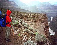
Tucson - Jul 24, 2002 Dams are not just a 20th Century phenomenon in Grand Canyon. As early as 1882, geologists realized that the Colorado River was blocked several times in the past by huge lava dams. They theorized that these dams -- formed when lava from volcanoes on the rim flowed into the canyon -- were slowly worn away as water flowed over them. But now geologists have found evidence that some of these dams didn't slowly waste away. Instead, some burst catastrophically -- in one case unleashing a massive flash flood carrying 37 times more water than the largest ever recorded on the Mississippi River. They also found that the Colorado River has been cutting down the eastern Grand Canyon twice as fast as the western end due to fault offsets. This has formed what are essentially giant slot canyons in the Inner Gorge (below the Tonto Plateau) and Marble Canyon. (Marble Canyon is on the Colorado River between Lee's Ferry and Desert View.) This down-cutting happened so fast that it's causing geologists to alter their estimates of the canyon's age. Growing numbers of geologists now believe that Marble Canyon and the Inner Gorge may be no more than 700,000 years old -- veritable infants on the geologic time scale, and much younger than the earlier 3-million- to 5-million�year-old estimates. Some scientists now believe that a third of the canyon's depth may have been cut in the blink of a geologic eye -- perhaps during the past 600,000 to 700,000 years. In addition, much of the excavation may have happened during a series of short, violent events that were linked by long periods of little change. This runs counter to previous theories that say the canyon formed slowly and continuously through uplift of the Kaibab Plateau and steady, day-by-day erosion by water and wind. The Hurricane and Toroweap faults, which cross the Colorado River in western Grand Canyon, are the most active in Arizona. Researchers at the University of Arizona, USGS and University of Utah have found that both faults have been very active during the past two to three million years, dropping in western Grand Canyon and creating knickpoints that move upstream. Knickpoints can be thought of as waterfalls that are formed when one side of a fault drops lower than the opposite side. Hikers walking the Bright Angel Trail can see a similar 200-foot fault offset in the Coconino and Redwall layers. This offset created breaks in those formations that form a natural route into the canyon on which the trail is built. As the Colorado River flows over a knickpoint waterfall, it quickly erodes the streambed at the lip and the knickpoint moves upstream. The greater the volume of water flowing over a knickpoint, the faster it cuts upstream. USGS hydrologist Robert H. Webb says there has been plenty of water flowing down the Colorado during the past million years -- much more than flows today. Outwash from Rocky Mountain glaciers during the Pleistocene (2 million to 11,000 years ago) may have generated flows in excess of a million cubic feet per second (cfs) because of the sheer volume of melting ice. Historically, the largest flow recorded on the Colorado River was 300,000 cfs in 1884. USGS scientist and University of Arizona graduate Jim O'Connor, along with UA hydrologist Victor Baker and others, also has found evidence of a 400,000 cfs flow that occurred about 4,000 years ago. The only flow that is comparable to Pleistocene flows would be if Glen Canyon Dam failed. "Large sustained floods can cause rapid downcutting in bedrock," Webb said. The Inner Gorge and Marble Canyon are essentially giant slot canyons: features consistent with rapid down- cutting, he noted. George Billingsly, of the USGS in Flagstaff, found further evidence for a young Grand Canyon in the western part of the canyon, just downstream of Havasu Canyon. His research suggests that solid rock stretched across the canyon at the level of the Esplanade only 770,000 years ago. That means the Inner Gorge that now drops 2,000 feet below the Esplanade was cut since that time. More evidence of the age of the Inner Gorge comes from 600,000-year-old lava flows in western Grand Canyon that lie near current river level in the vicinity of both the Toroweap and Hurricane Faults. If both the 770,000 and 600,000 year dates are correct, the presence of these lava flows suggests that the river may have downcut quickly in geologic terms. While knickpoints and downcutting tell much of the story in eastern Grand Canyon, lava dams have been a major force in the western part of the canyon. Webb and University of Utah researchers Cassandra Fenton and Thure Cerling are finding evidence of massive floods from failure of lava dams. They have recorded at least 5 major floods that occurred between 100,000 and 525,000 years ago after volcanoes erupted on the canyon's rim, spewed lava into the gorge and blocked the Colorado River. These lava dams were inherently unstable because molten basalt met cold river water and rapidly cooled, forming fragile walls of glass. "When basalt hits water, it shatters into glass, and there is just glass all over the place in these deposits," Webb says. When large dams fail catastrophically, such as Idaho's Teton Dam did in 1976, they leave distinctive profiles in soils and on canyon walls. The water drops quickly with an exponential decay curve. "We have that curve preserved from a lava dam that failed in Grand Canyon 165,000 years ago," Webb says. For this to happen, the dam had to fail almost instantaneously. The Teton Dam, for instance, failed in less than two hours. Webb estimates that the resulting flows from the lava dam were up to 15 million cfs -- 37 times larger than the largest known Mississippi River flood. "These were some high dams," Webb says. "We estimate some were more than 1,500 feet tall." Because the dams were unstable, the lakes that formed behind them had short life spans. Webb believes they filled quickly under pressure from large flows of Pleistocene snowmelt. These reservoirs did not leave deltas, which is consistent with this theory. Northern Arizona University scientists recently verified that the lakes were short-lived, Webb added. Webb, Fenton and Cerling collaborated on the fieldwork that supports this theory of catastrophic failure in the lava dams. Webb is an adjunct faculty member in the University of Arizona departments of geosciences and hydrology and water resources. Fenton will join the USGS and UA Desert Laboratory as a post-doctoral scientist next month. They applied a cosmogenic dating method developed by Cerling to date basalt flows and other landforms in the Grand Canyon. The technique measures how long a surface has been exposed to cosmic rays from space. Their application of this technique to lava flows in western Grand Canyon makes this region the best understood in terms of the ages of volcanic features in the Southwest. Guided by Billingsley, they dated a lava flow at 1,300 years old, making it of comparable age to Sunset Crater near Flagstaff as the most recent volcanic features in Arizona. Related Links University of Arizona SpaceDaily Search SpaceDaily Subscribe To SpaceDaily Express  Salt Lake City - Jul 19, 2002
The hotspot, which powers the geysers and hot springs of Yellowstone has produced over 142 massive volcanic eruptions during the past 16.5 million years -- far more than the 100 previously known blasts, University of Utah geologists found.
|
| ||||||||||
| The content herein, unless otherwise known to be public domain, are Copyright 1995-2016 - Space Media Network. All websites are published in Australia and are solely subject to Australian law and governed by Fair Use principals for news reporting and research purposes. AFP, UPI and IANS news wire stories are copyright Agence France-Presse, United Press International and Indo-Asia News Service. ESA news reports are copyright European Space Agency. All NASA sourced material is public domain. Additional copyrights may apply in whole or part to other bona fide parties. Advertising does not imply endorsement, agreement or approval of any opinions, statements or information provided by Space Media Network on any Web page published or hosted by Space Media Network. Privacy Statement All images and articles appearing on Space Media Network have been edited or digitally altered in some way. Any requests to remove copyright material will be acted upon in a timely and appropriate manner. Any attempt to extort money from Space Media Network will be ignored and reported to Australian Law Enforcement Agencies as a potential case of financial fraud involving the use of a telephonic carriage device or postal service. |