| . |  |
. |
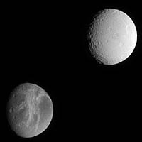
Cassini offers this lovely comparison between two of Saturn's satellites, Dione and Tethys, which are similar in size but have very different surfaces. Extensive systems of bright fractures carve the surface of Dione (1,118 kilometers, or 695 miles across). The double-pronged feature Carthage Linea points toward the crater Turnus at the nine o'clock position near the terminator, and Palatine Linea runs toward the moon's bottom limb near the five o'clock position. In contrast, the surface of Tethys (1,071 kilometers, or 665 miles across) appears brighter and more heavily cratered. The large crater Penelope is near the eastern limb. The huge rift zone Ithaca Chasma, which is 3 to 5 kilometers (2 to 3 miles) deep and extends for about 2,000 kilometers (1,200 miles) from north to south across Tethys, is hidden in shadow just beyond the terminator. For comparison, the Grand Canyon in Arizona is about 1.5 kilometers (1 mile) deep, and about 450 kilometers (280 miles) long. The image was taken in visible light with the Cassini spacecraft narrow-angle camera on March 7, 2005, at a distance of approximately 1.5 million kilometers (908,000 miles) from Tethys and 1.6 million kilometers (994,000 miles) from Dione. The image scale is 9 kilometers (6 miles) per pixel on Tethys, and 10 kilometers (6 miles) per pixel on Dione.
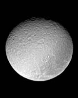
Pasadena CA (JPL) Apr 21, 2005 The ancient and battered surface of Saturn's moon Rhea shows a notable dark swath of territory near the eastern limb in this image from Cassini. This view shows principally the Saturn-facing hemisphere on Rhea (1,528 kilometers, or 949 miles across). North is up and tilted 40 degrees to the right. The image was taken with the Cassini spacecraft narrow-angle camera on March 7, 2005, through a filter sensitive to wavelengths of ultraviolet light centered at 338 nanometers. The view was acquired at a distance of approximately 1.8 million kilometers (1.1 million miles) from Rhea and at a Sun-Rhea-spacecraft, or phase, angle of 30 degrees. Resolution in the original image was 10 kilometers (7 miles) per pixel. The image has been contrast-enhanced and magnified by a factor of two to aid visibility. Related Links SpaceDaily Search SpaceDaily Subscribe To SpaceDaily Express  Pasadena CA (SPX) Apr 17, 2005
This map of Titan's surface illustrates the regions that will be imaged by Cassini during the spacecraft's close flyby of the smog-enshrouded moon on April 16.
|
| |||||||||||
| The content herein, unless otherwise known to be public domain, are Copyright 1995-2016 - Space Media Network. All websites are published in Australia and are solely subject to Australian law and governed by Fair Use principals for news reporting and research purposes. AFP, UPI and IANS news wire stories are copyright Agence France-Presse, United Press International and Indo-Asia News Service. ESA news reports are copyright European Space Agency. All NASA sourced material is public domain. Additional copyrights may apply in whole or part to other bona fide parties. Advertising does not imply endorsement, agreement or approval of any opinions, statements or information provided by Space Media Network on any Web page published or hosted by Space Media Network. Privacy Statement All images and articles appearing on Space Media Network have been edited or digitally altered in some way. Any requests to remove copyright material will be acted upon in a timely and appropriate manner. Any attempt to extort money from Space Media Network will be ignored and reported to Australian Law Enforcement Agencies as a potential case of financial fraud involving the use of a telephonic carriage device or postal service. |